In dry years like this 2021, well owners and operators are encouraged to safely monitor the trends in the level of the groundwater. Recognizing the seasonal influences on their aquifer, one well owner northeast of Albuquerque, has taken an important step toward increasing awareness on this issue by establishing groundwater level monitoring on his well. In coordination with the NM Bureau of Geology and it’s growing Collaborative Groundwater Monitoring Network, groundwater level data are streaming real-time for this region along with many others across the state.
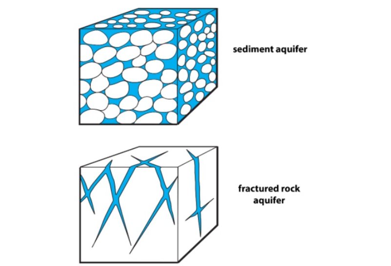
Groundwater, New Mexico’s largest source for drinking water, is found in aquifers accessed typically by wells which pump the water to the surface. Aquifers are recharged – or refilled – when water percolates through overlying rock and soils and refills the aquifer rock unit. In the northeast region of Albuquerque along the slopes of the Sandia Mountains, some homes are completely reliant on groundwater provided from domestic wells. In this area northeast of Albuquerque, the groundwater is found in a “fractured rock aquifer.”

(source: NM Bureau of Geology – https://arcg.is/SyGHm)
Fractured rock aquifers store groundwater mostly within fractures and larger openings in the rock. Unlike basin fill or sediment aquifers – where water is stored in spaces between grains of sand and gravel – fractured rock aquifers have very little water stored within the rock itself. Fractured rock aquifers can only store the water that fills existing fractures or larger openings within the rock, and they tend to be able to hold much less water than sediment aquifers. The result of having less water in storage is that in years where there is limited recharge by snowmelt or rain, fractured bedrock aquifers may not produce as much water as in wetter years, and the water level can change dramatically in dry years or when pumping.
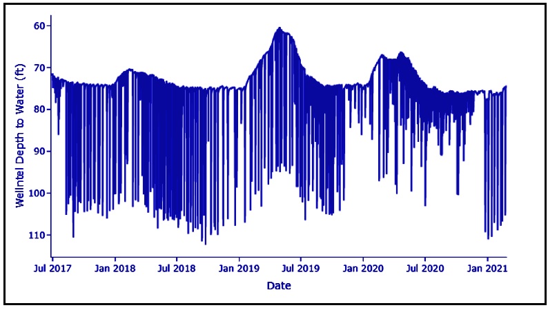
Looking at the hydrograph from the well northeast of Albuquerque, an increase in the groundwater level in the well can be seen as a rising trend (especially noticeable starting around January 2019 and January 2020). These increases indicate that winter snowmelt is providing recharge to the aquifer, with an increase in the water level in the well. The vertical lines shown on the graph represent the drawdown that occurs when the pump is used. The water level returns to its static level after water pumping ceases.

Monitoring trends in our aquifers over many years and maintaining data on all of our water resources is an important activity for a arid state like New Mexico. The NM Water Data Initiative is working hard to bring together many of these different data types to help provide a clear and dynamic picture of our water reality. Look for groundwater level data under “water quantity” on our data catalog, found here.
Get more information about the Collaborative Groundwater Monitoring Network with the New Mexico Bureau of Geology.
And if you have a well that’s gone dry, help us track that important data too – using this form.

