Our Mission: To make finding water data simple.
In 2019, New Mexico took the steps to build the tools to improve and integrate water data. Only the second state to recognize the importance of building a modern, agile water data infrastructure, New Mexico enacted 2019 NM House Bill 651 to share, integrate and improve the management of water data. This includes data on water quality, quantity and uses. This future-looking project is a multi-year endeavor, and is critical in responsive and responsible water management and water planning by and for the people of New Mexico.
Our Vision
Our Goals
- Provide accessible water data for decision-making, research, public inquiry, management, and planning to the people of New Mexico
- Provide easy access to key water datasets
- Create common water data standards and definitions
- Identify and prioritize data gaps
Background
In 2019, New Mexico enacted the Water Data Act (NMSA 1978, § 72-4B) to identify, share and integrate key water data. The Water Data Initiative (WDI) is the project convened by the New Mexico Bureau of Geology and Mineral Resources (NMBGMR), involving state “directing agencies” including the Office of State Engineer (OSE), Interstate Stream Commission (ISC), Environment Department (NMED) and Energy, Minerals and Natural Resources Department (EMNRD).
The legislation has launched a multiyear effort of communication and collaboration among these agencies and others collecting or managing water data for the state. Other key partners, including the Internet of Water, Sandia National Laboratories, and Earth Data Analysis Center, have been instrumental to our progress.
Water Data Partners and Sponsors
How we’re doing it
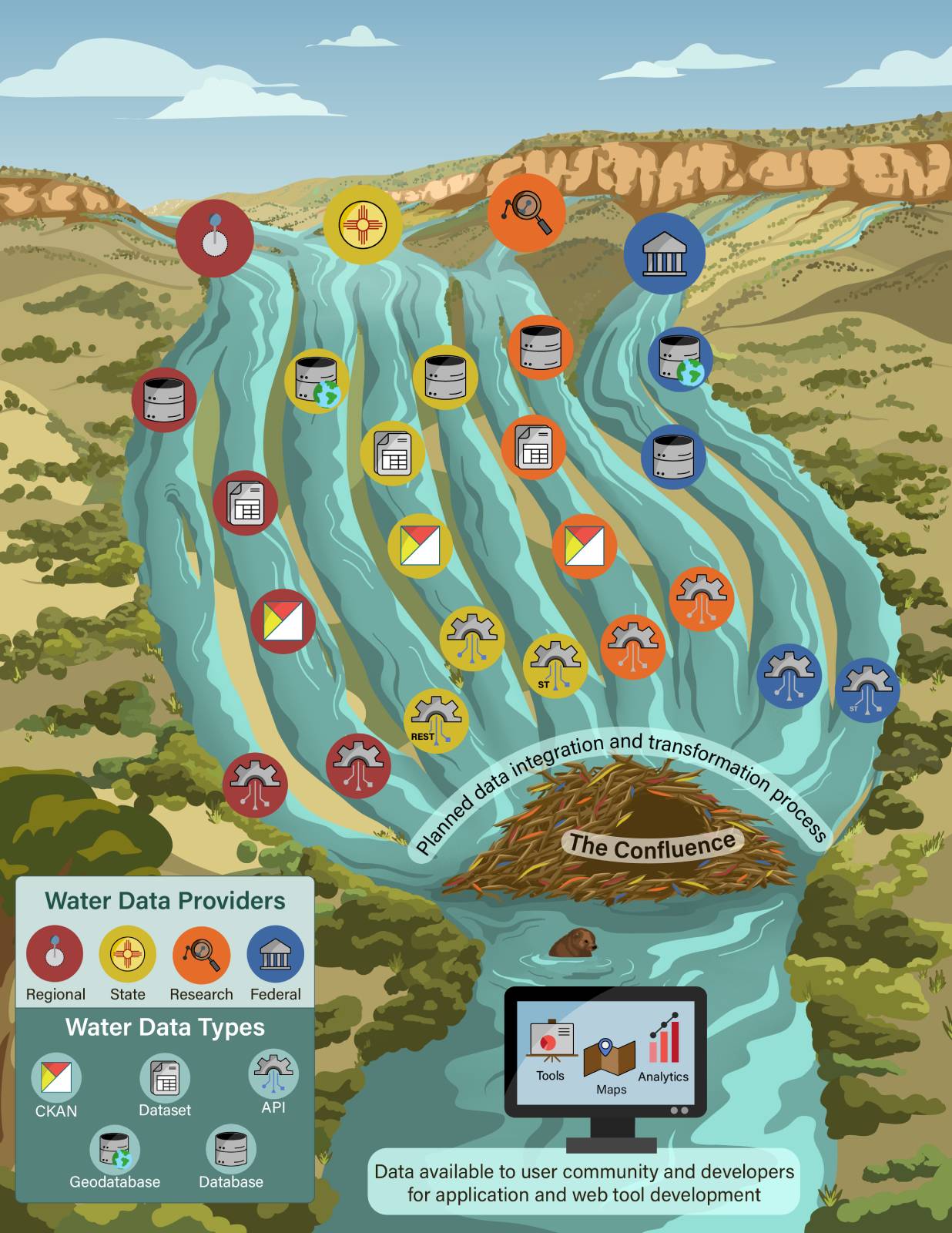
To help visualize some of the complexity and data flow required to fully integrate water data, this braided stream visual depicts the combination of “water data streams” from multiple regional, state, research, and federal data providers. These data providers, at the top of this figure, are the tributaries.
Each data provider can be considered an individual stream that is a tributary flowing toward a “confluence” of multiple data streams. Data providers with various internal data systems, such as databases or spreadsheets, can make data available in different ways, which are shown as channels on this figure.
Although each channel represents different methods of internally storing and externally sharing data, each can be shared via API. An API (application programming interface) allows a computer to share data with other computers, servers, or programs. Data shared on the internet via API are available for developers to use to make dashboards or interactive maps.
The goal is to bring all channels together at a confluence, shown as a beaver dam in this illustration, that integrates all of the data into a coherent whole.
